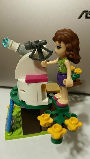
Being a mobile star dome, we travel all over the UK to bring space science to our learners. Luckily, there are sat navs to show us directions and seamlessly guide us through busy traffic, road closures and congestion. But how did people get to their destinations and determined their whereabouts before the sat nav era?
Today’s challenge is to learn to calculate the coordinates the old-fashioned way. Are you ready?
What is a coordinate system?
On Earth we specify one’s position using two coordinates: latitude and longitude. We think of them as a grid made of latitude and longitude lines.
Latitude lines, or parallels, run horizontally and parallel to the equator. Latitude tells us how far North (values 0 to 90 degrees N) or South (values 0 to 90 degrees S) we are from the equator.
Longitude lines, or meridians, run vertically from the North Pole to the South Pole so that they cross the Equator at a 90 degree angle. Longitude is measured relatively to the Prime Meridian that runs through the Greenwich Observatory: West (values 0 to 180 degrees W) and East (values 0 to 180 degrees E).
Every point on Earth lies on the intersection of a specific parallel and meridian – its unique coordinates.
How to find your latitude (Northern Hemisphere only)
A long time ago people have notices that when you move South, the North Star appears closer to the horizon, when you move North, the North Star appears higher in the sky.
In fact, it is easy to show that the height of the North Star above the horizon (or rather the elevation of the Celestial Pole above the horizon, but the two are nearly the same thing) is equal to the observer’s geographic latitude. Therefore to determine our latitude all we have to do is to measure the elevation of Polaris above the horizon! Well, provided you know how to find it first, of course (and here is how). Alternatively, you can use the elevation of the Sun at noon. But if using this method, remember to never ever look at the Sun directly!
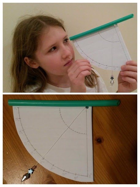
Now that you found the North Star, you can determine its elevation using a very simple tool called quadrant (quarter of a circle) or its close relative sextant (sixth of a circle). These instruments have been used for navigation since early times and you can easily make one yourself.
At night, look through your quadrant’s viewer (we made it out of straw) to find the North Star. Then read the number the string with the weight will be pointing at. That’s your latitude!
How to find your longitude
Figuring out your longitude will require a little bit more work. You will need a clock, a phone, a good friend at Greenwich and a sunny day.
The idea behind this method is fairly simple:
In one 24 hour long day the Earth makes one 360 degree turn. That means the Earth rotates at rate 1 degree per 4 minutes (or 15 degrees per hour). Therefore if you find out the time difference between the solar noon at your location and in Greenwich, you will figure out your longitude!
To find the moment of your local solar noon, draw a North-South line on the ground. Then stick a long pole into the ground so that it is in the middle of the line. Remember: the taller the pole and the more accurate its vertical position, the better! The moment the shadow cast by the pole will cross the North-South line is your local noon!
To find the time of the solar noon at Greenwich, ask your Greenwich friend to do the exact same experiment. Alternatively, you can use the Greenwich time signal (the 6 “pips”) on BBC Radio 4 to find out the Greenwich Mean Time.
You want to learn two things from this experiment: whether the Greenwich peeps come before or after your local noon and by how much.
- The Earth rotates counterclockwise (as seen from the “top”). So if your noon is earlier than Greenwich noon, you are located to the East of the Prime Meridian. Otherwise you are located to the West of the Prime Meridian.
- The longitude value can be calculated by using a “1 degree longitude for 4 minutes time difference” formula.
Now you know how to find you whereabouts without the sat nav! How cool is that? You will never get lost again!
Still curious?
Read more about Satellite navigation and how it works in our blog. And, as always, feel free to email your questions and comments to our inflatable planetarium team. We would love to hear from you!